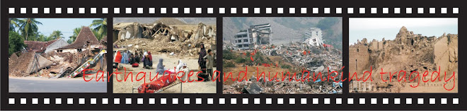
The epicenter was relatively very close and shallow to the object of Javanese houses
According to USGS, the magnitude was 6.2 Ritcher scale and the epicenter was at 7.96°S, 110.46°E with 10 km depth. The epicenter was located in the Opak river estuary around 20 km from Yogyakarta with shallow depth. It means that the source of the quake was on the site of the houses (Bantul district of Yogyakarta). The magnitude would have less meaning if the proximity to the epicenter is also less by means far away from the energy resource. Some other earthquakes actually stroke later such as the 7.0 SR West Java Province on September 2, 2009 with the epicenter distance 195 km from Jakarta and 46.2 km depth under the sea (USGS 2009a). In this case, it was causing casualties ‘only’ 57 fatalities and 300 injured from about 10000 damaged houses. This earthquake was also felt from Yogyakarta and Central Java but it has no effect or little, if any, to the buildings there. The other earthquake happened in November 13th with 5.4 SR magnitude 360 km away from Jakarta and 41 km depth (USGS 2009b). The last quake has no any casualties and building damage. In this matter, the MMI scale is more useful in measuring the effect earthquake to the buildings since it based on the impact in the area. If the 2006 Java earthquake has VIII-IX, while the September 2, 2009 west Java earthquake only VI-VII.
Geological formation of the sites bolstered up the effect to the buildings
Instead of spreading to the surrounding site in radial way, the 2006 Java earthquake had different effect in some areas related to the local geological condition. Soft soil easily amplifies shear waves transfer from epicenter. MAE recorded that horizontal peak ground accelerations in the region of 0.20~0.34g and vertical ground motion is estimated from structural collapse back-analysis at 0.18~0.30g which was categorized very high (Elnashai AS, et.al, 2007). As a result, buildings located near river line or wet land will be affected more. From the 2006 earthquake data, the nearer area of the epicenter, Gunung Kidul has less effect since the ground is more rigid constituted from limestone. In other hand, farer area as Klaten Regency with most wet agricultural soil has more collapsed houses. Unfortunately, as a consequence of agricultural land, Bantul and Klaten have sit on soft soil and will have more threat from earthquake disaster compared to surrounding areas. The wet areas stretched from Bantul to Klaten are also known as Opak vault.
The affected areas have very high density of houses
Java Island in general is the densest population in the world by 979/km². Among of them, Bantul district where collapsed houses were high is the densest area in Java with population of 831,955 living in 226,777 houses in 506.85 km² area or 1641.4/km² of inhabitants and 447.4 houses in every km² (DEPKES 2007). When the 2006 earthquake stroke, 148,440 out of 218,345 houses (67.9%) in Bantul were non inhabitable or badly damaged and collapsed (BAPPENAS 2006).
The houses structure was very weak and built without earthquake consideration
Eventhough Javanese houses were originally constructed from wood, the modern development shows that brick is the most material used for structural system of the houses. According to Boen (2006), the houses collapsed from Java 2006 were mostly built by masonry either with or without reinforced concrete frame. The weak masonry was the main factor to collapse of the building while for the newer with reinforced concrete; improper connection is the most aspect of structural failures. Those structural failures were mainly because of lack in earthquake consideration since 1943 when big earthquake, for the last time, was causing high casualties before it happen again in 2006.

Figure Javanese House's Changes in Material Structure
The load bearing brick-wall construction has been used widely as preferred house construction system together with timber frame since the Dutch occupied Java Island and started to colonize it in the early 17th century till recent times (Prijotomo,1996). For Javanese, the brick house then has been used as a symbol of social status of family of the owner (Koentjaraningrat, 1984). Unfortunately, this new concept was followed without any consideration in earthquake potential threat. The limitation of their economy and the lack awareness of proper construction of the houses were some of the main problem. As a result, this became one of factors contributing the weakness of the house construction and causing so much loss by recently quakes.
Based on Paper:
Idham, N; Mohd, M, and Numan, I (2010a) ”Why The Javanese Houses Have Failed In The 2006 Earthquake”, in proceeding of the International Conference on Sustainable Built Environment (ICSBE 2010) pp.121-128. Faculty of Civil Engineering and Planning, Islamic University of Indonesia, August 2010.

Tidak ada komentar:
Posting Komentar